Soil quality index: Stuttgart’s experience
Stuttgart’s Bodenindikation
As part of the activities to monitor European best practices regarding no net land take and to improve urban resilience, the SOS4Life project organised a study visit to Stuttgart, a leading city in environmental policies for reducing soil consumption.
Stuttgart is situated close to the Black Forest and the Neckar River, in a valley surrounded by hills, but where numerous industries are located. For this reason, it is an area that is historically characterised by quite significant levels of pollution.
From 1900-2000, the percentage of urbanised territory compared to the total rose exponentially – from 6% in 1900, to 28% in 1980, shooting up to 50% in 2000.
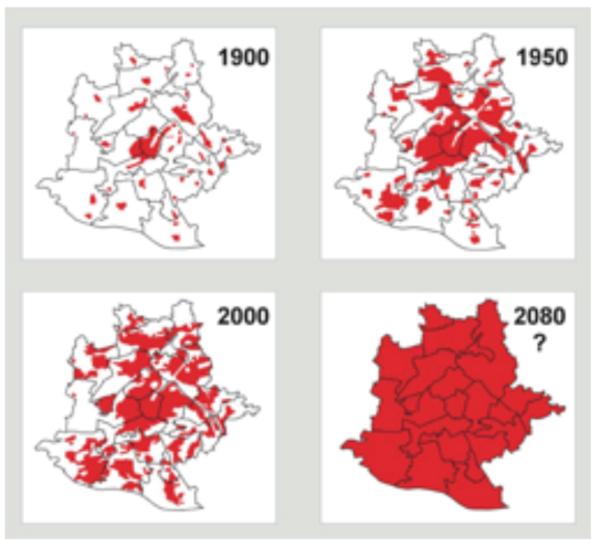
Changes in soil consumption in Stuttgart – Source: Landeshauptstadt Stuttgart Amt für Umweltschutz
The municipal administration realised that by maintaining this land take trend, by 2080 all available urbanised surface areas would be depleted.
Therefore, given that the development model adopted until then was clearly no longer sustainable and thanks to the shared desire of administrators and citizens to preserve and protect the soil, at the start of the 2000s the city decided to adopt planning and management tools capable of reducing the quantity of new urbanised areas.
The methodology adopted and applied in Stuttgart from 2006 on can be summarized briefly in the following points:
- mapping soil quality – meant as the capacity of soil to provide ecosystem services – with levels ranging from 0 to 5 (1: very low – 5: very high);
- measuring land take using a consumption index that takes into account not only the quantity, but also the quality of land consumed;
- fixing an objective in terms of annual consumption points;
- monitoring land take (with biennial checks and reports);
- favouring development within the urbanised territory (redevelopment and regeneration of urbanised areas) and limiting external development (new urbanisation) as far as possible, even if compensated;
- safeguarding soils of better quality through legislation.
On the basis of this methodology, soil quality means the sum of the ecosystem functions to protect from anthropogenic influences, including pollution and soil sealing, and the founding principle is protection of soils with the highest quality levels; in other words, those that guarantee the best efficacy in terms of climate and support to life.
The parameters taken into consideration in order to assess soil quality are:
- filtration and buffering function (clay content, humus, soil pH value);
- water purification and storage capacity;
- organic substances;
- hydraulic functions;
- biodiversity;
- type of soil.
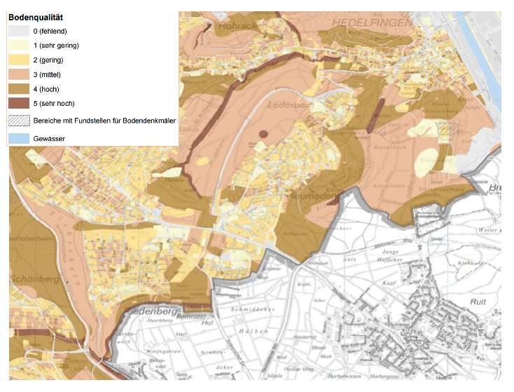
Soil quality map
To support planning decisions, the so-called soil index was elaborated, as the product of quantity and quality of the soils examined, and every two years a report is drafted on the state of progress of achieving the objective of limiting land take, whilst it was established that every soil consumption action in the external area (new urbanisations) should be compensated by de-sealing already sealed areas.
However, for the Municipality of Stuttgart, de-sealing is not a decisive compensatory tool. Not only; although it is advantageous for small sealed surface areas in particular, it is less so for larger areas. It is the idea of compensation itself that is not considered to be complete because, no matter how much is compensated, it is not possible to recover all the ecosystem functions of soil lost through transformation and sealing and the technical interventions for guaranteeing the return of functions are often very expensive and in some cases, extremely difficult to achieve. De-sealing is not therefore considered a tool capable of neutralising the environmental damage caused by the consumption of new soil.
In line with the city’s objective of achieving, in the near future, external soil consumption (on new areas) close to zero, the rehabilitation and regeneration of urbanised territory and the recovery of abandoned sites (even those to be reclaimed) are favoured, using a development strategy within the urbanised territory that notably reduces new land take (even if compensated).
In particular, in order to support this strategy of reconversion of urbanised areas and create new urban sectors (residential, commercial or mixed), the Municipality of Stuttgart has introduced a project for managing abandoned sites by setting up an online database offering information regarding the lot, its building potential, the number of floors that can be built, the end use and availability of the area. For example, in the map below, the blue dots indicate development sites for commercial purposes, the red dots indicate development sites for residential purposes and the red and blue dots indicate mixed end-use.
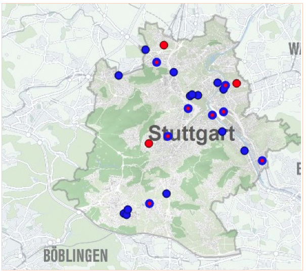
Stuttgart: map of areas to be regenerated
Starting a monitoring system, setting a maximum point score for land take and creating a land register of brownfields to be regenerated are the tools that have helped to significantly decrease the consumption trend of virgin land in the city, making Stuttgart one of the leading European cities for soil protection-related policies.

